


The Formosat-8A (FS-8A) satellite, which was launched on November 29 of last year, has begun transmitting its first high-quality images back to Earth. According to the Taiwan Space Agency (TASA), the transmission started after the completion of all functionality checks, orbital maneuvers, and the testing of over one hundred images. This event marks a significant milestone for Taiwan’s indigenous space program, demonstrating a major leap in its sovereign space capabilities.
Beyond Expectations: First Results
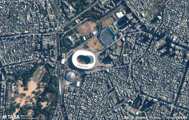
TASA reported that the satellite’s performance has been exceptional, stating that the “image clarity and signal-to-noise ratio exceeded the original design specifications.” FS-8A is designed to capture images with a 1-meter resolution, which can be enhanced to 0.7 meters through post-processing, a significant improvement over its predecessor, Formosat-5. The first batch of images included detailed views of Hsinchu Science Park, Tainan’s Anping District, Kaohsiung’s Singda Harbor, Japan’s National Stadium in Tokyo, and Barcelona Airport. Unlike its predecessor, which could only capture blurred traffic flow, Formosat-8A can photograph individual airplanes and vehicles in detail.
A Strategic Asset for the Nation
The imagery obtained from Formosat-8A will be utilized for a wide range of applications, including ensuring national security, cartography, agricultural management, and monitoring natural disasters. The satellite is a critical tool for enhancing Taiwan’s resilience and strategic autonomy, particularly in disaster response and security assessments. In addition to its primary imaging mission, FS-8A is equipped with scientific instruments to study atmospheric electricity and ionospheric physics, contributing to space weather forecasting and global communications safety. The satellite can also capture “red-edge” band images, which are highly sensitive to chlorophyll and plant health, making them invaluable for precision agriculture and forestry monitoring.
The Grand Plan: An Eight-Satellite Constellation
Formosat-8A is the first of an ambitious eight-satellite constellation for Earth observation. The full deployment of the constellation is expected by 2031. This network will provide global coverage and be capable of imaging Taiwan up to three times a day. Of the eight satellites, six will have a 1-meter resolution, while two will feature an even higher 0.5-meter resolution. The second satellite in the series, Formosat-8B (FS-8B), is nearing completion and is scheduled to be launched on a SpaceX rocket by the end of the current year.
A Look to the Future: Taiwan’s Place on the Space Map
The success of Formosat-8A, named the “Chi Po-lin Satellite” after the late Taiwanese documentary filmmaker, signifies a crucial step for Taiwan in the global space sector. By developing its own satellite network with a high percentage of domestically produced components, Taiwan reduces its reliance on foreign nations for critical geospatial data. This program not only strengthens national security but also fosters the growth of a local space industry supply chain. As Taiwan continues to develop its space capabilities, including plans for its own launch vehicles, the Formosat-8 constellation solidifies its position as a significant player in the international space community.